


Hiking in Morzine
A look at a few of my favourite walks in & around Morzine
The Portes du Soleil is famous for its skiing, snowboarding and cycling, but it doesn’t stop there. You don’t have to hop on a bike to experience the incredible beauty of the region, simply put on your walking shoes.
Whether you’re looking for somewhere new to take your dog, you want to improve your fitness or perhaps you’re even in need of a break from cycling or skiing, there are loads of walks, hikes and trail runs out there for you to try. Each and every one of them showcases the incredible beauty of the Portes Du Soleil and they can be as long or short, difficult or easy as you want to make them. The weather improved and I went out in search of some you might like to try!
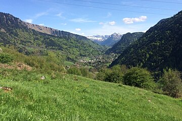
I accidentally stumbled across my first hike when looking after a dog in Saint Jean d’Aulps, and it’s turned out to be my favourite! If you head out of the centre of the village, up the road that takes you to the Grand Terche, (Route de la Moussiere d’En Haut) you’ll easily find the path. Its after about two hairpin turns along the main road and takes you through the woods. The route eventually brings you out to a gravel track with a sign which points towards Graydon.
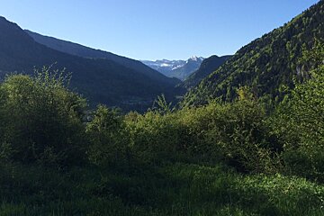
Follow this track, which runs parallel to the Ruisseau (stream) des Favets, for about 40 minutes. It’s quite slow going because of the gradient but the terrain is good and there’s plenty of shelter. You get to a group of chalets and the path opens up into the most stunning valley. With a rocky ridge circling the edge and grassy banks covered in wild flowers, it took my breath away. As you continue to walk, this view just keeps getting better!
[Use IGN map: 3528ET : Morzine Massif Du Chablais]
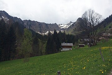
In the height of summer, I’m told the sound of cow bells ring out across the valley, which adds to the charm of the stunning spot. When you get to the heart of the village there’s a tiny, picturesque church, sitting on the top of a small hill, here you’ll find another sign. The sign offers you a number of options. It points the way to a number of peaks including Col De Graydon, Col de la Basse and Le Crozet. Each take around 2 to 3 hours to get to and aren’t for the faint hearted.
If you’re out for a gentle hike, you’ll probably feel like you’ve done enough already, similarly if you’re doing a fell run, you’ll have clocked up a decent distance. The round trip from Saint Jean to Graydon will take you about 3 hours. HOWEVER. There is a road you can drive on to get to Graydon if you want to make it your starting point and attempt some of the trickier climbs.
Another walk, which is something quite special, is a hike out of the little hamlet of Bas Thex. Park up near the little church and head over a little bridge, the path will then start to emerge in front of you. It’s a little grassy track that takes you in the direction of the village of Le Biot. The steep path takes you up, high above the hamlet, looking out over the rock, known to locals as the “elephant rock”. There are spots to stop off the whole way, with water troughs for thirsty dogs (and humans).
When you’ve been walking for about an hour, a sign will give you a number of options, we picked to continue walking to Drouzin. It’s an unrelenting climb. The views however, are incredible. Eventually you emerge out of the forest, and be prepared to be stunned. The view spans across the ragged edge of the Roc de Jotty but also reaches as far as the banks of Lake Geneva and Mont Blanc. The round trip will take you 4-5 hours.
[Use IGN map: 3528ET : Morzine Massif Du Chablais]
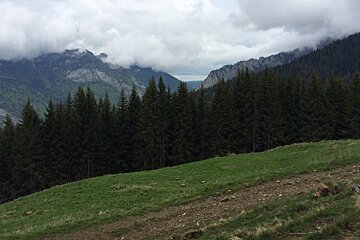
Another favourite hike of mine is the walk up the Pointe de Nyon. Starting at the Nyon telecabine car park you follow signs past the Nyon waterfall taking you through the woods up to the peak. Again, it’s a steep climb but with plenty of shelter you can take it easy. Sections of this route feature on the trail des haute fort run, so it’s also a good training spot for fell runners.
Eventually the wooded area opens up revealing stunning views across Morzine. You then follow the track around the side of the mountain, which is quite hairy at times. Handrails and ropes are wedged into the side of the rock should you need a helping hand. You eventually come out at the plateau de Nyon and can either continue to climb or begin your descent back to Morzine. It’s a round trip of about 4 hours.
[Use IGN Map: 3530ET : Samoens Haut-Giffre]
I’m writing this with my OS map open in front of me and can see I haven’t even scratched the surface! Don’t worry- watch this space - I’ll find plenty more for you to try before the summer is out!
-
Find some more suggestions for walks here, and read our hiking guide for tips and advice.